In this assignment we created maps that our groups will use to navigate the woods through the Priory in Eau Claire Wisconsin. The maps that were created used two different types of grids that will be used on our maps. The grids that were created used two different styles. The styles are UTM with 50 meter intervals (Figure 1), and Geographic coordinates using decimal degrees (Figure 2). The two maps that were created could be used differently in different situations. In my opinion the UTM grid will be more useful for this assignment. The maps that were created needed to have plenty of deal but had to be balanced so that they was not too much going on making them difficult to read.
Figure 1: The map shows the grid of the UTM zones. From this image the labels are very difficult to read. Included in the orange are contour lines, and the yellow box shows the area that we will be working in.
Figure 2: This map shows the gridlines that were created using the decimal degrees. This image is in a different coordinate system giving it the uneven look.
In figure 1 the coordinate system used was Nad 1983 UTM Zone 15. This stands for Universal Transverse Mercator. This system puts zones into vertical columns. In this case Wisconsin is located primarily in zones 15 and 16 (Figure 3). This coordinate system I believe will allow for a more precise map.
https://upload.wikimedia.org/wikipedia/commons/thumb/8/8d/Utm-zones-USA.svg/220px-Utm-zones-USA.svg.png
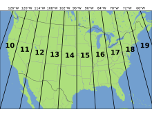
Figure 3: This image shows the UTM zones for the majority of the United States. Wisconsin is located in zones 15 and 16.
Figure 2 uses Nad 1983 Wisconsin TM (meters). This is a state plane coordinate system. This is a coordinate system just for that state. This means that within that state the map could be extremely accurate, but the farther out you move the less accurate it becomes.
I am very curious to see which of the maps that were created will be the one that is more helpful. Precision is necessary and this exercise should be a great way to show which of the coordinate systems is more accurate.
No comments:
Post a Comment